Organization of environmental monitoring as the construction of complex spatio-temporal series of transformation of various biogeocenoses under the influence of natural and anthropogenic factors based on a system of observations, assessments and forecasts of the state of the natural environment, continues to remain at a rather low level. The reason for this lies in the lack of a unified methodological approach and comprehensive implementation of monitoring programs for individual environments, influencing factors and components of biota. This can rightfully be attributed to monitoring epidemiological situation, for example, during the fight against malaria [1].
Monitoring of bioproduction processes as a complex system of monitoring, assessment and forecasting changes in the state of the environment, includes monitoring of flora and fauna.
Assessing and monitoring the impact of an object on the environment using biological indicator objects is impossible without determining the parameters of biological objects. And if we talk about the spread of malaria, then its implementation is often complicated by difficult access to water bodies where malaria mosquitoes live and breed.
The introduction of representatives of the genus Gambusia Sp., which eat mosquito larvae, into reservoirs, is recognized as an effective means of combating malaria. The effect of combating malaria will be achieved only when this introduction is carried out over large areas of often inaccessible terrain. The problem of control over the introduction processes arises, which in modern conditions can best be solved by remote (aerospace) methods. We can talk about remote methods focused on the use of digital photography from light drones (UAVs). The use of such methods may encounter problems due to the presence of camouflage protective coloration (CPC) in representatives of the genus Gambusia sp.
Lightweight UAVs are currently increasingly used in field research in the field of ecology and biology [2]. They also find their use in ichthyologic research [3, 4]. The use of digital photography from a UAV for remote recording of small, shallow-water representatives of the ichthyofauna will in many cases encounter problems associated with the presence of their CPC. Elimination of its masking effect will also be required when using UAVs for remote registration of Gambusia Sp.
There are many methods and technologies for spatial image processing that are successfully used in environmental and epidemiological monitoring. Thus, work [5] describes a procedure for processing digital images of coastal shallow sections of the river bottom, which is based on the principles described in work [6]. It makes it possible to identify changes in system parameters that serve as markers of the appearance of small representatives of the ichthyofauna comparable to Gambusia Sp. Namely, identification in conditions similar to the places of induction and habitat of Gambusia sp. compatible with the use of light UAVs using methods.
The purpose of the work is to develop a technology for processing digital images of water areas, based on processing digital images of areas of shallow water areas and the analysis of the relationships of diversity and evenness in the color of aquatic organisms for remote registration of introduced Gambusia Sp.
The technology under development involves component analysis of the RGB model and subsequent quantification of the G/(R+G+B) and R/G ratios in the image. According to the results of this analysis, the ratio of green chlorophylls and yellow-orange-red pigments in the phytocenosis is determined (fig. 1).
After image preprocessing (filtering and quality improvement) by analyzing the components of the RGB model of digital photos, the values of the original colorimetric parameters are found.
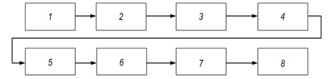
Fig.1. Structural diagram of the technology for digital images processing of aquatories for remote registration Gambusia Sp.: 1 – сollection of information about the population of biological objects;
2 – image filtering using a high-order digital filter; 3 – exclusion of artifacts; 4 – forming an array of colorimetric parameters; 5 – determination of interactions between the standard and the biological object; 6 – determination of the trajectory of the dynamics of the development of a biological system on the basis of discrete modeling of dynamic systems; 7 – identification of biological objects; 8 – forming a conclusion.
The main processing of digital images is carried out within the framework of the procedure, which includes the following operations:
- dividing the image into segments;
- division of each segment into sub-segments;
- determination of the values of parameters G/(R+G+B) and R/G in each sub-segment;
- determination of average values and mean square deviation of parameters G/(R+G+B) and R/G for a set of sub-segments of each segment. These parameters are indicators of the amount of green chlorophyll and yellow-orange-red pigments in the phytocenosis;
- determination of Spearman's correlation values between the average values and values of the mean square deviation of the G/(R+G+B) and R/G parameters for a set of segments of each photo;
- analysis of the differences between the photos by Spearman's correlation values between the average values and the mean square deviation values of the parameters G/(R+G+B) and R/G.
Thus, a technology was developed that can be used in systems for automatic and automated remote registration of Gambusia Sp., introduced into reservoirs for malaria control.
References:
1. Vysotska Olena, Nosov Konstantin, Hnoevyi Igor, Porvan Andrii, Rysovana Lyubov, Dovnar Alexandr, Babakov Mikhail and Kalenichenko Marharyta, Image processing procedure for remote recording of the Gambusia sp. introduced into a water for anti-malaria. Technology Audit and Production Reserves, 2022. 2(63), 14–18. doi: https://doi.org/10.15587/2706-5448.2022.252297, Available at SSRN: https://ssrn.com/abstract=4067653.
2. Whitehead K., Hugenholtz C. H., Myshak S., Brown O., Le Clair A., Tamminga A., Barchyn T. E., Moorman B. Remote sensing of the environment with small unmanned aircraft systems (UASs), part 2: scientific and commercial applications. Journal of Unmanned Vehicle Systems, 2014. 2 (3), 86–102. doi:10.1139/juvs-2014-0007.
3. Groves P. A., Alcorn B., Wiest M., Maselko J. M., Connor W. P. Testing unmanned aircraft systems for salmon spawning surveys. Facets 1, 2016. 187–204. doi:10.1139/facets-2016-0019.
4. Kudo H., Koshino Y., Eto A., Ichimura M., Kaeriyama M. Cost-effective accurate estimates of adult chum salmon, Oncorhynchus keta, abundance in a Japanese river using a radio-controlled helicopter. Fisheries Research, 2012. 119–120, 94–98. doi:10.1016/j.fishres.2011.12.010.
5. Grigoriev A. Ya., Levchenko A. V., Ryabovol A., Vysotska O. V., Kalashnikova V. I. Distance reading fishes in the water area by colorimetric parameters related to productivity and diversity of phytobentos. Матеріали ІV Міжнародної науково-практичної конференції «Інформаційні системи та технології в медицині» (IСM–2021): зб. наук. пр. – Харків : Нац. аерокосм. ун-т ім. М. Є. Жуковського «Харків. авіац. ін-т», 2021. 57-58.
6. Bespalov Yu., Kabalyants P., Zuev S. Relationships of diversity and evenness in adaptation strategies of the effect of protective coloration of animals. bioRxiv, 2021. 05.06.441914; doi: https://doi.org/10.1101/2021.05.06.441914.
|